Wing Dams: Reshaping the River
By Barry Drazkowski
Wing and closing dams on the Upper Mississippi are a favorite haunt for many species of fish and favorite places for thousands of people fishing for bass and walleye. They can also be the nemesis for the novice boater who inadvertently encounters these rock structures with their motor's prop. A lesson learned once is then paid for through expensive repairs. Like most things on the river, we take them for granted; they are there and must have been there forever. Well, sorry, no.
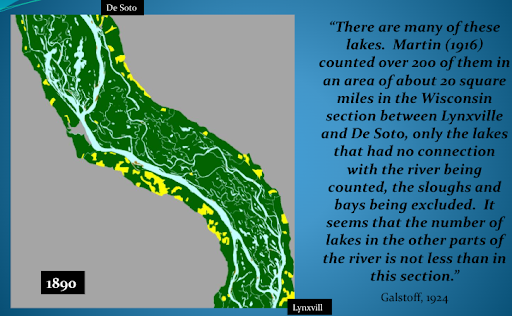
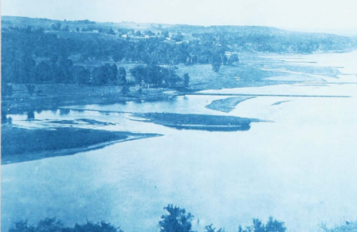
In 1878, Congress authorized a sweeping program to change the future of the Upper Mississippi River by creating a 4 ½ foot navigation channel, which was eventually expanded to a six-foot channel. The goal was to direct more of the river's water down the designated navigation channel through the placement of rock wing dams and to close off side channels, pushing even more water down the new navigation channel. These structures were built from limestone quarried from the adjacent river bluffs, like the Richtman Quarry at Fountain City. The rock was quarried, hauled to the construction site on barges, and then placed in the wing/closing dam location by layering the rock between mats of woven willow. We should remember that prior to this time, the river had few rock structures and was an ancient landscape dating back over 6,000 years. It was a rich diversity of backwater lakes, ponds and braided channels making up the historic floodplain that humans interacted with for centuries.
Now and into the future, the river is forever changed. Management focus has shifted from this landscape typified by a variety of human uses to one focused on navigation. The channelizing project worked: water was shunted from the backwaters into the main channel, wing dams pushed the water into the middle of the main channel, scouring and eroding it into its intended depth, and predictable navigation began. The rock was also used to armor the shoreline in areas that were eroding to stabilize those places. We have realized the consequences ever since.
As water was shunted to the navigation channel, three major changes occurred in the river. First, it created a massive number of new rock structures. They became a critical habitat for species like the redhorse and a preferred habitat for smallmouth bass and walleye, forever attracting people fishing for these species. They also had the impact of capturing the sand eroded by the increased flows. The sand built up in the quiet areas behind the wing dams, building up new shorelines and islands, eventually becoming the new river shoreline, as witnessed in the upper portions of Pool 5A. Second, filling the spaces between wing dams resulted in growing the islands they were attached to, eventually adding more forest adjacent to the channel. The third real significant change occurred in the historic floodplain. The channels and lakes that so typified the river for the previous centuries were now cut off from consistent flow. The slower-moving water meant any river-carried sediment began to deposit in our once-dynamic floodplain. At the same time, settlers began to plow the river's watershed, slowly converting this long-lived prairie and woodland landscape into an agricultural landscape, slowly surrendering its valuable soil through erosion into our now-changing river. As more and more sediment enters the river, more and more of our watershed is captured in slowly filling channels and ponds, putting our precious backwaters on a trajectory of habitat loss through sedimentation.
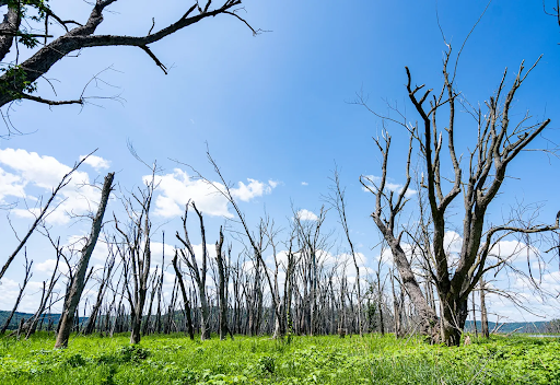
Today, we realize this long-term change as we look at what is left of our historic floodplain. The locks and dams built in the 1930s to incentivize increased river navigation by creating a nine-foot channel have masked the impact of the wing dams. The resulting pools eroded the historic landscape, filling the diverse array of lakes and streams in the lower two-thirds of most pools. The remnants of our historic floodplain lie in the upper third of most pools. Those areas are where we see the ongoing impacts of the long-ago built closing and wing dams. Lakes and ponds we fished and hunted are now marsh, willow, or forest. Those channels we so freely navigated or fished with net and setline are almost gone, replaced with shallow bars. Our river is a tapestry of historic human influences, rock and dams, erosion and sedimentation, and continued habitat loss every year.
The question I leave each of you with is this: do we watch patiently as the last of our precious river succumbs to the influence of rock and dams, an eroding watershed, and collecting sediment in the remaining channels and lakes, where the incredible floodplain of history is but stories and memories we share with our children? Or do we see an opportunity to let the river once again function as it did for centuries? Could we balance an economically justified navigation strategy with one where small parts of the river once again become what they were long ago?