
Bumpy Road for the Federal Conservation on the Upper Mississippi Is Smoothing Out, Maybe.
By Alderwoman Olivia Dorothy
Important work founded by the Izaak Walton League was threatened in 2025 by proposed budget cuts, but those cuts appear to be smoothing out somewhat. Here’s a glimpse at what we’ve almost lost and are still trying to protect, and why it’s important.
Upper Mississippi River Restoration
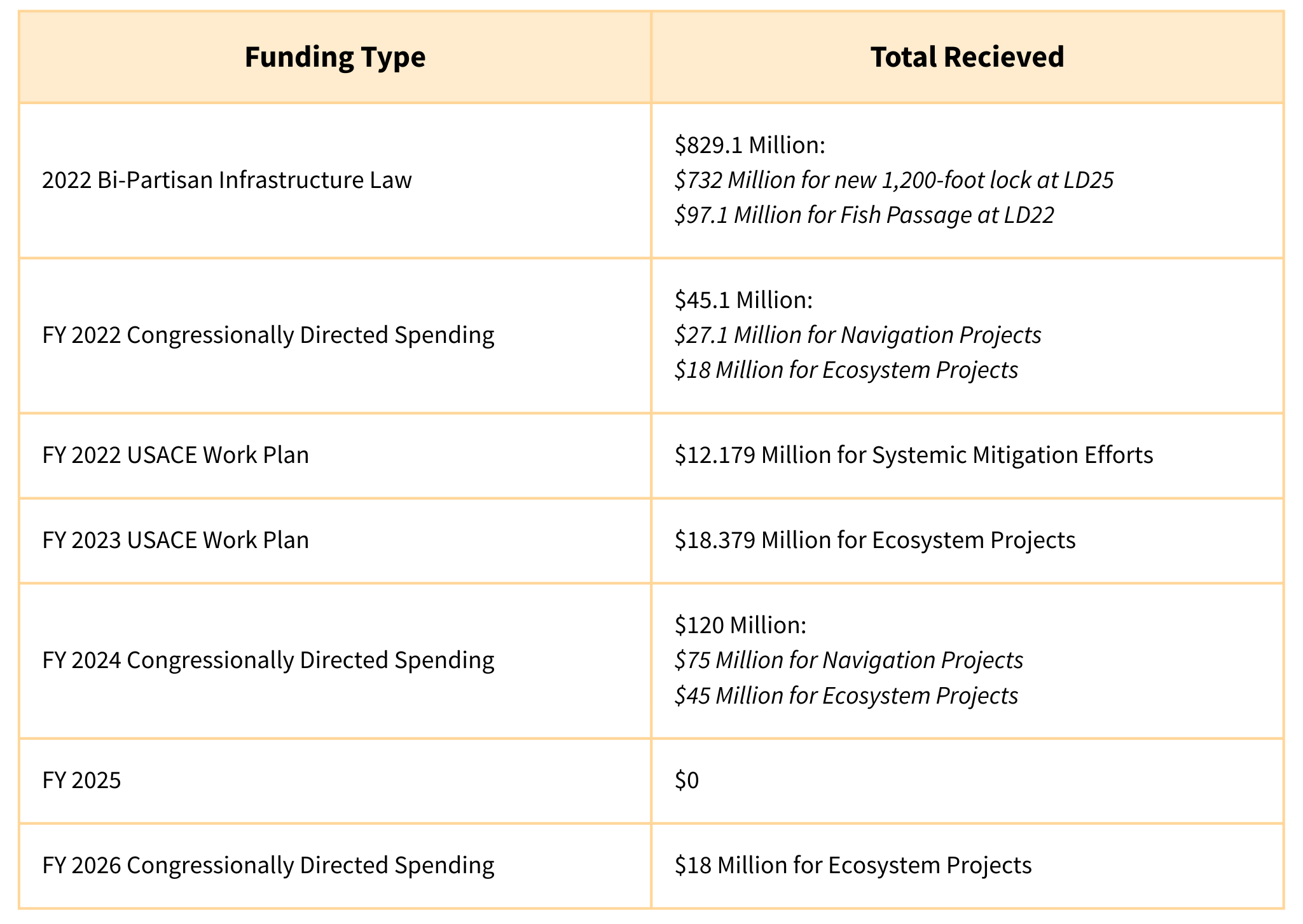
Fiscal Year 2024 saw an all-time investment high for Upper Mississippi River Restoration, with $55 million spent on Habitat Rehabilitation and Long-Term Monitoring. But in 2025, the rug was pulled out from under the wildly popular Upper Mississippi River Restoration Program. As Congress and the Administration fought over budget priorities, Mississippi River advocates learned of sweeping cuts to restoration programs nationwide.
One Mississippi and partners, including the Izaak Walton League, responded quickly to the threats. The call to protect the Upper Mississippi River Restoration Program resulted in 4,000 letters to Congress in just five days, begging them to protect the Program. And Congress listened. When the dust settled on the 2025 Federal Budget, the Upper Mississippi River Restoration Program was allocated $13.516 million. One of only a few restoration programs to be awarded any of the scarce 2025 appropriations. In FY2024, the UMR Restoration Program was one of 17 similar restoration programs funded by Congress. In FY2025, the UMRR was one of only seven to receive appropriations.
Confident on the heels of our success in 2025, we were excited to see the President include $52 million for UMR Restoration in the FY2026 budget request. Again, one of only a handful of restoration programs to be recommended for funding in 2026. But that excitement over our success was short-lived when we realized that the president’s budget proposal included the elimination of the US Geological Survey’s Ecosystems Mission Area and significant declines in the US Fish and Wildlife Service's budget.
This was troubling because the Long-Term Monitoring component of the UMR Restoration Program is built on the foundation of the US Geological Survey’s Ecosystems Mission Area. While the UMR Restoration Program provides funding for additional science and monitoring on the Mississippi River, that work is based out of facilities like the Upper Mississippi Environmental Sciences Center in LaCrosse, where the US Geological Survey’s Ecosystem Mission Line pays for office space, equipment storage, server space, administrative support, and other foundational elements of a functioning workspace.
Likewise, the US Fish and Wildlife Service saw significant cuts to its program areas, particularly the National Refuge System, which manages most of the Habitat Rehabilitation and Enhancement Projects completed through the Upper Mississippi River Restoration Program. These cuts pulled staff off of important project inspections and reviews. And the workforce attrition over the last year has left the Service woefully under-resourced to manage extensive land and water areas.
Thanks to outreach to Congress from groups like One Mississippi and the Ikes, the US Geological Survey Ecosystem Mission will be fully funded in FY 2026. And more resources will be available for Refuges.
But issues remain. This month, the Refuge system is undergoing a review of “mission alignment” within the Department of the Interior. While the Administration is soliciting feedback from field staff within the Service, there are concerns that the review is moving so quickly that it’s hard to believe staff input is being taken into account. The administration appears to be focused on selling refuge land eliminating and field staff, who are essential to protecting fish and wildlife resources. Given the Upper Mississippi River Refuge’s focus on providing access to hunting and fishing, we can be hopeful that the Refuge will remain in tact, but the reduction in staffing will undoubtable harm resources, if it hasn’t already.
What about the Navigation and Ecosystem Sustainability Program
The Ikes, like many conservation and environmental organizations, have been critical of the dual-purpose navigation capacity expansion and ecosystem rehabilitation program. Because the proposed new locks cost more than the economic revenue they will create, the program is not eligible for recommendation under Administrative rules. This means that Congress must allocate funding through earmarks.
Since the program restarted, some projects have advanced. In contrast, other components of the program have lagged; for example, the feasibility study approved by Congress found that cumulative impacts mitigation would be required with the expansion of lock and dam capacity on the Mississippi River. Despite $12 million in funding for "systemic mitigation," there's still no plan to address the cumulative impacts. And financing for ecosystem projects is significantly lower than promised. In 2024, the Izaak Walton League signed onto a letter with partners that expressed concern about the Corps failure to develop a systemic mitigation plan that complied with federal law. Since this time, the Corps has still failed to develop a systemic mitigation plan.
Despite these issues, the Corps has used NESP funding to develop the next generation of habitat projects. This process (called Reach Planning) evaluates segments of the Upper Mississippi and Illinois rivers to determine restoration priorities across the different reaches.
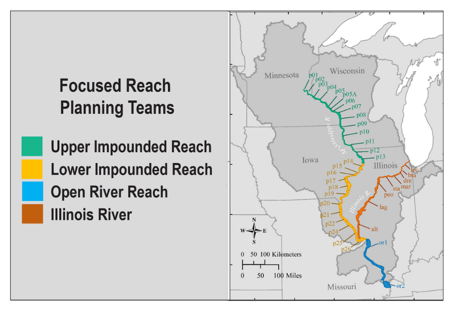
The updated Reach Plans will identify ecosystem problems, such as climate change, and make recommendations for the Corps to implement through the habitat rehabilitation programs (NESP and UMRR). These recommendations may include specific projects to be constructed or modifications to existing projects to address new issues.
The Izaak Walton League worked with partners at One Mississippi to engage in the Reach Plans to identify emerging issues threatening habitat on the Upper Mississippi River and new sites that would benefit from habitat projects. The Ikes partnered with Audubon and One Mississippi to host a workshop in LaCrosse to discuss ecosystem needs in the Upper Impounded Reach. The Ikes also signed onto a detailed comment letter with partners that identified many areas along the Upper Mississippi River where floodplain reconnection, restoration, and reforestation would greatly benefit rare, threatened, and endangered species. We also emphasized the importance of ensuring that ecosystem projects benefit fish and wildlife and of considering how biodiversity loss is playing out on the Mississippi River.
In FY2026, NESP will receive $18 million for ecosystem restoration and we hope to move the Reach Planning forward to advance the many program and project concepts identified at the workshops. Meanwhile, we will continue to monitor federal appropriations and how changes at the federal level are impacting the Upper Mississippi River.
A History of the Corps on the Upper Mississippi River
As environmentalists, we often think of the Environmental Protection Agency (EPA) as the lead federal agency for water concerns due to its responsibilities under the Clean Water Act. However, while the EPA oversees water quality, the Corps is the primary agency responsible for shaping the physical environment of our coasts and inland waterways and for permitting construction activities in waters of the United States.
The US Army Corps of Engineers (the Corps) has an outsized impact on the Mississippi River. Established in 1775, the Corps supports American military operations and civilian infrastructure. The Corps’ civilian mission over time has ranged from land surveys to lighthouse construction to space exploration. Today, the Corps is the lead federal agency for water resources management (among its other specialities).
How did the Corps become the lead federal water resources agency?
As American colonists quickly moved West in the early 1800s, the government needed to develop reliable transportation corridors. Roads were built and maintained by local private and public entities, with dubious results, so waterways were often seen as the most reliable form of long-distance transportation. But rivers were periodically clogged with debris and uncharted. The Corps was assigned the task of mapping and maintaining rivers for travel and commerce. This was the beginning of over two centuries of water resources development projects on the Mississippi River.
Timeline of Corps Activities on the Mississippi River:
1824: Congress orders the Corps to clear debris for more reliable navigation on the Mississippi River.
1879: Congress establishes the Mississippi River Commission to develop and maintain navigation infrastructure in the main river channel and construct levees to promote agricultural development in the floodplain.
Late 1800s - Early 1900s: The Corps begins and escalates dredging the Upper Mississippi River to accommodate first a 4.5-foot, then a 6-foot commercial navigation channel.
1930-1963: The Corps constructs 29 locks and 28 dams to support a 9-foot navigation channel on the Upper Mississippi River via water control and dredging. The Izaak Walton League secures protection for the Upper Mississippi River Wildlife and Fish Refuge.
1936: Following the devastating Flood of 1927, Congress designates the Corps as the nation’s primary flood control agency - formalizing the Corps oversight of inland and coastal waterways and floodplains.
1972: The Clean Water Act was significantly amended to grant the Corps primary permitting authority over construction activities in waters of the U.S., although the Environmental Protection Agency continues to have veto power over the Corps’ decision-making.
1986: In response to the catastrophic collapse of aquatic vegetation on the Upper Mississippi River, and pressure from conservation organizations, including the Izaak Walton League, Congress authorizes the Corps to undertake only its second ecosystem restoration program - Upper Mississippi River Restoration Program (the first being the Comprehensive Everglades Restoration Plan created in 1948).
2007: Congress authorizes the Navigation and Ecosystem Sustainability Program to construct additional locks, other navigation efficiency projects, fish passage at some of the dams, and other ecosystem restoration projects on the Upper Mississippi River.
What has been the impact of 200 years of commercial navigation and flood control?
The Corps’ activities on the Mississippi River over the past two centuries have caused severe degradation of the Mississippi River ecosystem. Since 1824, the US Army Corps of Engineers have been altering the river to facilitate commercial navigation. These activities include removing woody debris, armoring banks, building levees and pump stations, constructing dams, and channelizing the river through dredging and river training structures. The majority of projects that the Corps has initiated on the Mississippi River over the last 200 years continue to be operated and maintained. And these projects touch almost every facet of the Mississippi River ecosystem.
The Mississippi River and its floodplain encompass roughly 30 million acres, representing about 0.5% of the North American landmass. Despite its relatively small size, it plays a vital role in supporting a significant portion of North American wildlife. This includes around 25% of all fish species and 60% of all birds in North America. Additionally, the Mississippi River provides drinking water to 20 million people (roughly 6% of the US population) and supports a $500 billion per year natural resources- and recreation-based economy, which provides jobs for more than 1.5 million people.
The Corps’ activities severely impaired the River and have really never never stopped or been mitigated. Virtually all of the navigation and flood control projects were authorized long before modern environmental laws that require ecosystem mitigation. The consequences of the last 200 years of Mississippi River development have had a major impact on the quality and quantity of habitat. Currently, only about 10% of the Mississippi River and its floodplain, or about 3 million acres, is considered fully ecologically functional or healthy. Most of this is in the upper most reaches of the Mississippi River where the River and floodplain are protected as parks or refuges.
What programs exist to help restore the Mississippi River ecosystem?
The Upper Mississippi River Restoration Program that was established in 1986 authorizes the Corps to work with Upper Mississippi River states and other federal natural resource agencies to do long-term resource monitoring and habitat rehabilitation and enhancement projects. The Upper Mississippi River Restoration Program is special because it is a “continuing authority,” meaning the program never expires and no new Congressional authorization is required to keep the program running, only annual appropriations.
The Navigation and Ecosystem Sustainability Program has been controversial from the beginning because there is not enough navigation traffic on the Upper Mississippi River to justify the expensive new locks. Due to this issue, the program has only received funding in fits and starts.
The Lower Mississippi River has not received investment funding for ecosystem restoration like the Upper Mississippi River, despite the Corps’ extensive levee and channel maintenance projects that have fragmented the Lower River’s habitat and caused significant degradation. In 2020, Congress authorized the Corps to conduct the Lower Mississippi River Comprehensive Study to develop recommendations for ecosystem restoration and other purposes. The Lower Mississippi River Comprehensive Study was appropriated $25 million between 2022 - 2027, but funding was recalled by the Trump Administration in Fiscal Year 2025.
Despite restoration programs, the Mississippi River remains highly degraded and impaired. Although the Upper Mississippi River Restoration Program has been working since 1984, it has only rehabilitated about 200,000 acres of Mississippi River habitat, which represents about 1% of the Mississippi River and floodplain landmass. Additionally, there is no federal plan to comprehensively address ecosystem and biodiversity needs on the Mississippi River.
While the Clean Water Act has greatly reduced water pollution from municipal and industrial sources, habitat loss continues to outpace restoration efforts at a rate of 3-4% annually, even on the Upper Mississippi River where a functioning habitat rehabilitation program has been working for 40 years. The damages are likely worse on the Lower Mississippi River, where ecosystem restoration efforts are only just beginning.
According to the Long-Term Resources Monitoring Program Status and Trends Reports that are developed under the Upper Mississippi River Restoration Program, the underlying drivers of ecosystem decline on the Mississippi River is the infrastructure that supports commercial navigation and flood control. However, state, and federal agencies along the Mississippi are reluctant to challenge, curtail, or remove any component of navigation or flood control infrastructure, even when that infrastructure is obsolete or poorly performing.
Despite the long-overdue need to assess the environmental impacts of commercial navigation and flood control on the Mississippi River and develop a cumulative mitigation plan, the Corps has never developed a mitigation plan for any part of the Mississippi River navigation or flood control systems.
While ecosystem restoration activities are great, they rarely go far enough. They are really designed to be “the icing on the cake,” with mitigation as the cake in this metaphor. Without meaningful and comprehensive mitigation to offset the ongoing impacts of navigation and flood control on the Mississippi River, restoration programs will have minimal positive impact.
This is why One Mississippi focuses on engagement with the US Army Corps of Engineers. Their outsized impact on the Mississippi River has had tremendous and devastating consequences for fish and wildlife. While some people have undoubtedly profited from the navigation and flood control infrastructure, the projects have and continue to displace indigenous people from tribal land (example: Prairie Island Indian Community). And historic African-American towns are often intentionally flooded to protect white-owned farmland (example: Pinhook, MO).
One Mississippi hopes to influence the Corps to promote projects that center the needs of the most vulnerable people, establish mitigation plans that address the ongoing impacts of the Corps’ activities, and broaden restoration efforts.
The Upper Mississippi River Restoration Program
The Upper Mississippi River Restoration (UMRR) Program rehabilitates and enhances habitat on the Upper Mississippi River and supports environmental monitoring and scientific research. As of 2023, the UMRR Program has rehabilitated habitat on over 121,000 acres of the Illinois Waterway and the Mississippi River north of the Ohio River confluence. The UMRR Program also hosts a Long-Term Research Monitoring program that studies the Upper Mississippi River environment to understand ecological trends. From 2016-2022, UMRR published 76 peer-reviewed studies and partnered in 59 research groups among federal and state agencies and universities.
Established in 1986, the UMRR Program was a first-of-its-kind environmental management and scientific monitoring program aimed at reversing the degradation of a large, multi-jurisdictional River. The program is housed at the US Army Corps of Engineers (Corps) and is a partnership between the US Fish and Wildlife Service, US Geological Survey, the US Environmental Protection Agency, US Department of Agriculture, US Department of Transportation, and the five UMR States (Minnesota, Wisconsin, Iowa, Illinois, and Missouri). The program offers several opportunities for the public to engage with River experts to discuss and plan habitat rehabilitation and scientific research.
Reversing the degradation of the Mississippi River requires significant investment. The Mississippi River has lost more than 90% of its historic floodplain, and the locks and dams on the Upper River have transformed those reaches into large reservoirs called “pools.” Only 10% of the 2,400-mile-long River is considered “healthy,” and most of that is in the very upper reaches. The River’s aquatic and floodplain habitat encompasses roughly 30 million acres.
Given the size of the Mississippi River, the UMRR’s progress to rehabilitate and enhance habitat on 121,000 acres seems like a drop in the bucket - less. But the UMRR Program makes a difference. Without the ongoing habitat projects, the River would be degrading even faster, and some habitat types might have been completely lost by now. The Program, though small, does provide habitat for many rare, threatened, and endangered species. Giving them a toehold in the highly modified Mississippi River.
What is habitat rehabilitation and enhancement?
Why not call it habitat restoration? The Upper Mississippi River is a modified system, with many dams, levels, and other modifications to facilitate navigation and other uses. The term “Restoration” refers to the act of returning the ecosystem to its historic or self-sustaining state, which isn’t happening on the Upper Mississippi River. Restoring the habitat on the Upper Mississippi River to its original state would require actions such as dam and levee removal, which would cause major economic disruptions. Habitat “rehabilitation” or “enhancement” seeks to recreate lost habitat within the modified system. The projects are not self-sustaining, and the habitat they create begins to degrade as soon as they are completed. Colloquially, it is common to refer to any habitat enhancement project as “restoration” because it returns an area to its natural state. However, because the underlying cause of habitat loss continues to operate, the project is not self-sustaining. This means that work on the Upper Mississippi River to save fish and wildlife habitat will never be completed unless the dams and levees are removed from the River.
What’s mitigation?
Most water resources projects require “mitigation” to offset the environmental impacts of development. Such work is part of the project cost and is subject to many rules and regulations to ensure habitat, wetlands, water quality, and other environmental impacts are truly offset. Habitat rehabilitation and enhancement programs are not financially tied to any particular projects, and while they generally offset human impacts on natural resources, they are not subject to the same strict rules and regulations as mitigation projects. Habitat programs are a valuable complement to mitigation efforts because so much damage has been done to the Mississippi River ecosystem over the 200-year history of navigation and flood control on the River. But restoration programs should never negate the mitigation required to offset specific projects and development programs on the River.
The UMRR Program is not a mitigation program; rather, it is a response to habitat degradation caused by inland navigation. It’s important because the inland navigation system on the Mississippi River has never been comprehensively mitigated. And its ongoing operation and maintenance impacts continue without mitigation. UMRR does not replace mitigation measures, but it helps slow the decline of habitat on the Upper Mississippi River.
The Navigation and Ecosystem Sustainability Program (NESP) is a dual-purpose program that expands navigation capacity and restores habitat on the Upper Mississippi River.
The story of NESP begins in the 1950s, when commerce on the Mississippi River took off and began growing at a rate assumed to be exponential. Planning for the first expansion project, the US Army Corps of Engineers finalized the design of the replacement for Lock and Dam 26 in 1969. Just a few months later, the National Environmental Policy Act (NEPA) was signed into law. Immediately, environmental organizations sued to bring the Lock and Dam 26 Replacement Project into compliance with the new statute. Environmentalists won the initial complaint, forcing the Corps to consider the project's environmental consequences.
Advocacy campaigns, led by the Izaak Walton League, and court battles over the next two decades highlighted the need to address the decline of the Upper Mississippi River ecosystem. In 1976, Congress authorized what was then called the Great River Environmental Action Teams to study the environmental impacts and develop a resource management plan for the Upper Mississippi River. This culminated in the creation of the Upper Mississippi River Restoration Program in 1986.
The Corps replaced Lock and Dam 26 in 1989 when it opened the Mel Price Locks and Dam. The new Mel Price structure included 600- and 1,200-foot lock chambers. Most dams on the Upper Mississippi River only have one 600-foot lock, and navigation interest groups and the Corps have continued to push for additional 1200-foot locks. Feasibility studies for larger auxiliary locks on the other dams continued into the 1990s. In 2000, the Army Corps of Engineers was subject to an Inspector General investigation that found it was manipulating the cost-benefit analysis to justify the construction of new locks on the Upper Mississippi.
This finding forced the Corps back to the drawing board on its plans to expand navigation infrastructure on the Upper Mississippi River. It was clear that objections from environmental interests would make it much harder to build new locks. So an idea was hatched to promise funding for habitat rehabilitation, in addition to lock construction. To secure support from environmentalists, the navigation interests and the Corps pledged to match the financing of both the construction of the new locks and other navigation efficiency measures, as well as habitat rehabilitation on the Upper Mississippi River.
Unfortunately, the new locks still did not pass muster in their cost-benefit analysis. But this information was not released until after Congress authorized the combined program in the 2007 Water Resources Development Act. With this new economic information, the Navigation and Ecosystem Sustainability Program has never been recommended for funding by any president since it was authorized. For a few years after it was initially approved in 2007, Congress earmarked funding for the program. Still, when Congress eliminated the earmark process, funds dried up. In recent years, Congress has reinstated earmarks, now called "congressionally directed spending," and added additional layers of transparency to track them. With this new process in place, NESP has begun receiving funding again.
Meet the author
Alderwoman Olivia Dorothy represents the 1st Ward in East Moline, IL, and works as an environmental advocate focused on restoring and protecting the Mississippi River. She is currently under contract with One Mississippi and is a Co-Chair of the Clean River Advisory Council in the Quad Cities. At One Mississippi, Olivia is helping their 75+ member organizations interface with the US Army Corps of Engineers projects and programs. As Co-Chair of the Clean River Advisory Council, Olivia helps promote and advance the Mississippi River Equity Vision in the Quad Cities. Her work in the Quad Cities builds capacity within organizations rooted in the local Black, Indigenous, and immigrant communities.
Over her career, Olivia has worked for prominent environmental organizations, including American Rivers, the Izaak Walton League, and Prairie Rivers Network. Early in her career, Olivia worked as a rivers and water policy advisor for Governor Pat Quinn and Lt. Governor Sheila Simon. Olivia has earned multiple awards for her work, including the River Action Eddy Award in 2016 and the U.S. Army Public Service Commendation in 2023. Olivia is a Certified Floodplain Manager, Master Gardener, and Certified Wildland Firefighter. Olivia has a Bachelor of Science in Natural Resources and Environmental Sciences and a Master of Arts in Environmental Studies from the University of Illinois.